Pfälzer Weinsteig Stage 5: Neustadt an der Weinstraße - St. Martin
No journey is too long! The longest stage of the Pfälzer Weinsteig will bring you closer to the sky, whilst standing firmly on the ground and becoming more aware of the wonders of nature. From the market square in Neustadt you hike uphill to the Hambacher Höhe and the Nollensattel to then reach the natural monument of Zigeunerfelsen with its observation deck. You continue uphill towards the Nollenkopf and pass the Speierheld Unterstandshütte and the natural monument Hambach Bergstein. From the Sühnekreuz it is now only a few steps to Hambach Castle which you should definitely not miss visiting. Over the Sommerberg it goes uphill to the Hohe-Loog-Haus that serves snacks with a view of the southern Palatinate. Equally promising is the highest point of the Palatinate Forest, the Kalmit, overlooking the Rhine valley 500 m below. Again you can enjoy a refreshment at the Kalmithaus. You now see an ocean of stones under the trees – an ocean of stones? This natural monument, the Felsenmeer, is bound to fascinate you before the path leads down the Totenkopfstrasse through the valley leading to St. Martin.
UFFBASSE! - Campaign for being considerate of others in nature
- Always act in a proactive, friendly and considerate way towards everyone you encounter along the way.
- Respect nature, do not destroy plants and always stay on the paths. Try to avoid excessive noise and leave the forest before dusk.
- Remember to take a rubbish bag with you when you go out and take your rubbish back home.
- Please keep your dog on a leash at all times. Other visitors and animals thank you.
- For your own safety, observe all road closures, including at weekends.
- Park only in designated parking areas. Leave space for emergency vehicles and agricultural machinery.
- Please give priority to agricultural and forestry traffic.
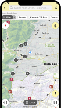
Route description
We start in the lively market square in Neustadt, making our way through the pedestrian zone and eventually beginning the ascent to the Nollensattel. From here, we follow an easy path on the slope through the chestnut trees, before a path begins the steep ascent past moss-covered rocks in the forest to the Zigeunerfelsen rock (1). The path continues upwards to the 490m high Nollenkopf (2) and along the ridge past the Speierheld hikers' hut (3) to the Hambacher Bergstein natural monument. From here, we hike on pretty paths to the stone cross and then towards Hambach Castle, which is always worth a visit.
We walk clockwise around the Sommerberg mountain to reach the Hohe-Loog-Haus (PWV) restaurant (4) where we can enjoy a meal and the view from the terrace over the southern Palatinate, stretching as far as Kraichgau and the Black Forest. Refreshed and ready to continue, we make the gradual ascent to the Kalmit (5). At the top of the highest peak in the Palatinate, we can enjoy fantastic views of the Rhine plain 500m below and, on Wednesdays and weekends, the hospitality of the Ludwigshafen hikers' hut (PWV).
South west of the Kalmit, on the Hüttenberg mountain, lies another highlight of our route – the imposing block field (6). From here, the trail leads us through the charming pine forests down to the Totenkopfstraße on the eastern edge of St. Martin, picturesquely situated at the end of the Kropsbach Valley. Passing the Bellachini lake (7), it's not far to the idyllic, heritage-protected historical town centre.
")
")
")
")
")
")
")
")
")
")
")
")
")
")
")
")
")
")
")
")
")
")
")
SÜW-App
Use our app as an interactive holiday planner:
- Detailed topographic maps
- Precise map base, also available offline
- Highlight recommendations from us for you
- Exact tour descriptions
- accessibility Informations
- Refreshments and overnight stays
- Sights and events
- Navigation function including voice output
- Planning your own tours at home
- Tracking your own tours on the go
- Get to know the environment better with skyline augmented reality