Eußerthal Rundweg 1
The circular hiking trail 1 leads from the centre of Eußerthal past the Birkenthaler Hof into Birkenthal.
The starting point of the hiking tour is the car park at the village community centre / fire brigade in the centre of Eußerthal. From the car park we turn right into Hauptstraße, then right again into Breitbachstraße. We continue to keep to the right and walk out of the village to the hikers' car park at the Birkental. Here we have to cross Taubensuhlstraße and follow the circular path straight ahead into Birkental. Past the Schweinswoog, the path winds northwards along the Eußerbach stream.
Cross a small bridge to reach a farm track, which leads to a crossroads on the right after a few metres. Here the trail turns right and heads back south to Birkenthaler Hof (refreshments available). Along Haingeraidestraße we return to the centre of the village to the village community centre, our starting point for the hiking tour.
UFFBASSE! - Campaign for a considerate coexistence in nature
- Always act with foresight, kindness and consideration towards everyone you meet along the way.
- Respect nature, do not destroy plants and always stay on the paths. Try to avoid excessive noise and leave the forest before dusk.
- Remember to bring a rubbish bag for the road and take rubbish home with you.
- Please keep your dog on a lead at all times. Other visitors and animals will thank you.
- For your own safety, observe all road closures, even at weekends.
- Park only in designated parking areas. Leave space for emergency vehicles and agricultural machinery.
- Please give priority to agricultural and forestry traffic.
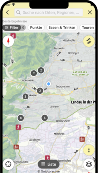
Route description
The circular hiking trail 1 leads from the centre of Eußerthal past the Birkenthaler Hof into Birkenthal.
The starting point of the hiking tour is the car park at the village community centre / fire brigade in the centre of Eußerthal. From the car park we turn right into Hauptstraße, then right again into Breitbachstraße. We continue to keep to the right and walk out of the village to the hikers' car park at the Birkental. Here we have to cross Taubensuhlstraße and follow the circular path straight ahead into Birkental. Past the Schweinswoog, the path winds northwards along the Eußerbach stream.
Cross a small bridge to reach a farm track, which leads to a crossroads on the right after a few metres. Here the trail turns right and heads back south to Birkenthaler Hof (refreshments available). Along Haingeraidestraße we come back to the centre of the village to the village community centre, our starting point for the hiking tour.
If you are travelling with a pram, you should not use the narrow path to the right at the junction at the end of the valley, but go straight on for a few metres. Then you will come to the same farm track that you reach via the little bridge. Here also turn right to the crossroads, then continue with the description (see above).
Are you looking for a barrier-free path? Then why not park at the hikers' car park opposite the Birkenthaler Hof and take the asphalted path into the Birkenthal. In this case, however, you cannot use a circular route, but have to go back the same way.
At the end of the valley, it is also possible to make a detour to the Böchinger Hütte. Just follow the red dot, mostly level path. Open on Sundays.
")
")
")
")
")
")
")
")
")
")
SÜW-App
Use our app as an interactive holiday planner:
- Detailed topographic maps
- Precise map base, also available offline
- Highlight recommendations from us for you
- Exact tour descriptions
- accessibility Informations
- Refreshments and overnight stays
- Sights and events
- Navigation function including voice output
- Planning your own tours at home
- Tracking your own tours on the go
- Get to know the environment better with skyline augmented reality